Permaculture Design - an Art and a Science
Permaculture design is more than a collection of sustainability ideas and methods – it organises them and puts them to work in an elegant, energy-efficient, site-specific plan. It requires art and science.
My permaculture design process is methodical in its approach. I go through a logical sequence of observation, measuring and analysis to arrive at a good design. This process sets up the conditions within the designer for the most elegant solutions to reveal themselves. After diligent survey and analysis work, a number of elegant solutions will be calling for attention to the mind of a creative individual.

Permaculture is a philosophy of working with, rather than against nature; of protracted and thoughtful observation rather than protracted and thoughtless labor; and of looking at plants and animals in all their functions, rather than treating any area as a single product system
Bill Mollison
Permaculture Design Sequence
- Survey
- Analyse
- Design
- Implement
- Maintain
- Evaluate
- Tweak
In permaculture design we often refer to this design squence with is to with its acronym SADIMET. It is a logical step by step process that helps the designer see the underlying form of the site and the its key characteristics and patterns before designing. It also allows for the realities of designing and working with nature. Inanimate products of design have a limited life-span while nature will carry on.
This methodical approach takes time, but far less than trying to retrieve an inefficient set-up arrived at in haste.

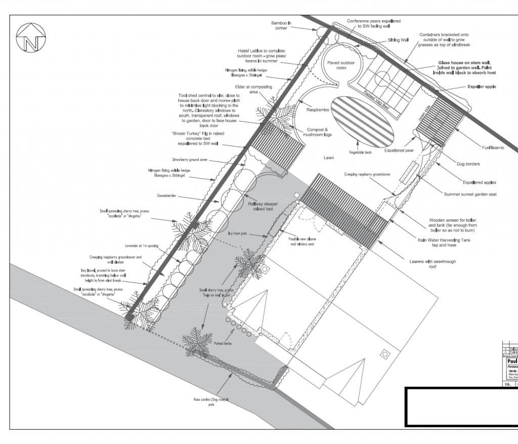
Small Garden Design
Later (in a moment of inspiration) I made a rough sketch of a possible layout. Later again I developed this further by moving and placing the elements of the design so as to create as many mutually beneficial relationships as possible between them.
I soon reached a natural conclusion with an elegant design that marries the needs of the people with the natural gifts and characteristics of the site.

Large Garden, Farm and Horticulture Design
A blank slate, of sorts
In order make useful observations about a site it is convenient to make those on a scaled map of that site, so those observations have context later on, and in relation to the other observations that will be made.
Often people think of a site map they imagine the design itself. However what is initially needed is a scaled site map with absolutely no design thoughts recorded. A blank slate of sorts is required, recording only the permanent pre-existing features that must be designed around or better again incorporated into the new design.
First therefore, one needs a scaled base map of the site to overlay one’s observations, analysis and ultimately design onto. In the early days I found my school and engineering skills in mechanical drawing very useful in producing such maps, but nowadays the most efficient way is by using existing satellite imagery.
Easy Base Maps with Google Earth
There is a very convenient method for producing scaled base maps using the Google Earth program – which is free to install and use. Before every garden, farm or community garden design consultation I make scaled, faded out base maps of the site in question using this system.
It’s such a useful system that I have made free tutorial videos about how to do this. Click here to read and view how to do it yourself: https://permaculturedesign.ie/permaculture-base-map/
Armed with these base maps I am ready to do the initial survey of the site.
Large Garden, Farm and Horticulture Design
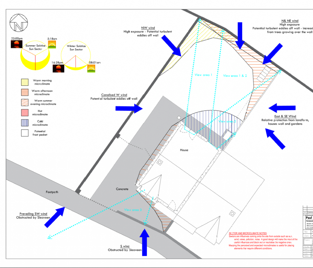
During the observation stage of every project it is vital to survey the land-form of the site. The aspect and gradient of the site is pivotal to how it will interact with the incoming energies of light from the sun, wind, rain and water flowing over the site. Neighbouring sites with differing land-forms will inevitably produce differing micro-climates.
For a stark example consider contrasting the micro-climate produced on a site on the south facing slope of a valley with those produced on a site across the valley on the north facing side. Even on the same site however these contrasting conditions will usually exist to some degree due to the subtleties of the land-form.
The ability to observe and predict the characteristics of these micro-climates is essential to good design, and is a pitoval part of the permaculture design process.
Getting the Lay of the Land
On small garden projects that don’t involve construction, it is quite feasible to judge levels by eye and with the aid of some simple tools such as an A-frame, bunyip and pond-builders level.
Elevation Contour Maps with Drone Mapping
On larger projects drone mapping is my go-to method for producing high resolution detailed, contemporaneous, scaled, elevation contour maps of the site. I expand on this wonderful system here in a special article: https://permaculturedesign.ie/drone-mapping/
Zen Garden Design Philosophy
Good permaculture design is a unifying discipline where art and science collaborate again. Uniting these seemingly separate modes of thought is fundamental to how we design and vital to heal an increasingly polarised world. We indebted to the late Robert Pirsig for developing this idea in his book Zen and the Art of Motorcycle Maintenance.
“The artist is not a special kind of man, but every man is a special kind of artist”
- Ananda Coomaraswamy